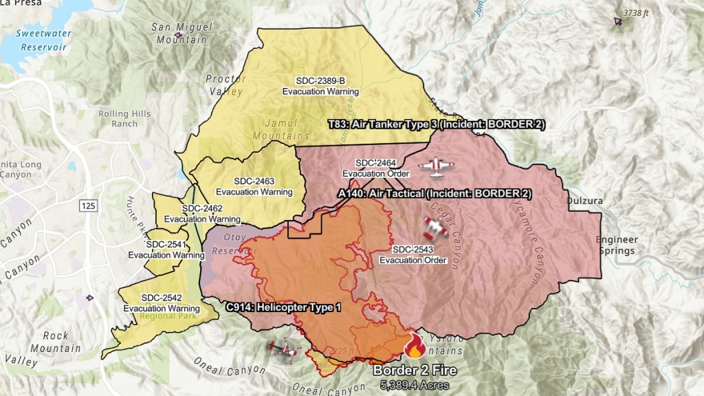
The Border 2 fire map reveals how far the flames have spread on Otay Mountain in San Diego County. By 11:24 PM PT on Friday, January 24, the fire has burned over 5,000 acres, having exploded in under a day after being first reported on Thursday at around 2:30 PM PT at having burned only 10 acres. The blaze is situated between the Otay Mountain wilderness near Tijuana and Chula Vista. Here’s the current status of the Border 2 fire map today.
What is the Border fire map on Otay Mountain today?
The Border 2 fire, as of 12:15 PM PT on Friday, has covered over 5,389 acres in San Diego County and is 10% contained according to Cal Fire. Mandatory evacuation orders have been issued for the zones in red, while those in yellow are under evacuation warnings.

The status report on the blaze at 10:45 AM PT states that firefighters saw “extreme fire behavior” on Thursday night. Multiple Fire-Hawk helicopters provided aerial support during the night, and other air tankers throughout the State have been flying fire suppression missions as well. Many resources, including 692 personnel, 10 helicopters, 8 dozers, and 23 engines, have been assigned to the fire thus far.
A smoke advisory for the Otay Mesa and surrounding areas southwest of the fire has been issued by the San Diego County’s Air Pollution Control District. The agency recommends that residents who smell smoke in the region limit any physical activities outdoors. It reports that winds will shift on Friday, blowing east and northeast by the afternoon.
Cal Fire Captain Robert Johnson, per Fox 5 San Diego, explained that while “the rate of spread of this fire and the fire conditions is not abnormal for this area,” it’s uncommon for the region to experience these conditions in January. He says that the vegetation has “spent all summer long drying out” and that it has not had “any measurable rain this rainy season.” Fortunately, rain is expected to fall in the San Diego area by Sunday.
San Diego firefighters have had to battle multiple wildfires over the last three days, including the Lilac fire, Rancho Bernardo fire, and the Gilman fire.


