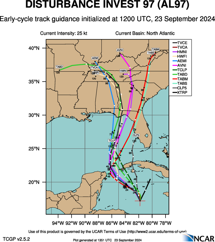
A tropical storm in the Gulf of Mexico is expected to develop into Hurricane Helene, according to weather experts who are tracking the system. In a September 23, 2024 forecast, the National Hurricane Center based in Miami, Florida believes that “a tropical depression or storm is likely to form within the next day or two” and that chances for it to form into a cyclone is at 90 percent. If current predictions hold, the storm will most directly impact residents in Florida. Here’s when Hurricane Helene is expected to make landfall.
When is Hurricane Helene expected to hit Florida?
Hurricane Helene is predicted to reach the Gulf Coast of Florida by Thursday, September 26, with wind gusts as powerful as 100-120 miles per hour.
This is according to Accuweather, which predicts that the storm will most likely hit the Florida panhandle and Big Bend region as a Category 2 Hurricane. However, AccuWeather’s hurricane expert Alex DaSilva believes that the current setup for the storm “has the potential to become the strongest hurricane landfall in the U.S.” for 2024.
Through to Saturday, September 28, it is believed that the region will experience 4-8 inches of rainfall with the landfall zone getting 8-12 inches of rain. In particular, the “Tampa Bay region is extremely vulnerable to storm surge.”

Most projections from the National Center for Atmospheric Research (NCAR) on September 23 predict that the tropical storm, labeled as AL97, will hit Florida. The tracked path of the system will be clearer over the next few days, but it is recommended that residents in Florida and other areas along the Gulf Coast begin to make preparations for the oncoming storm.
As for why this system is developing so quickly, meteorologist Ben Noll from the National Institute of Water & Atmospheric Research points out on X (formerly Twitter) that the seas along the west coast of Florida are about 2 to 2.5 degrees Celsius (that’s about 3.5 to 4.5 degrees Fahrenheit) higher than average. This means that the tropical storm has the potential to draw more moisture from the air and become a more intense hurricane than usual.


