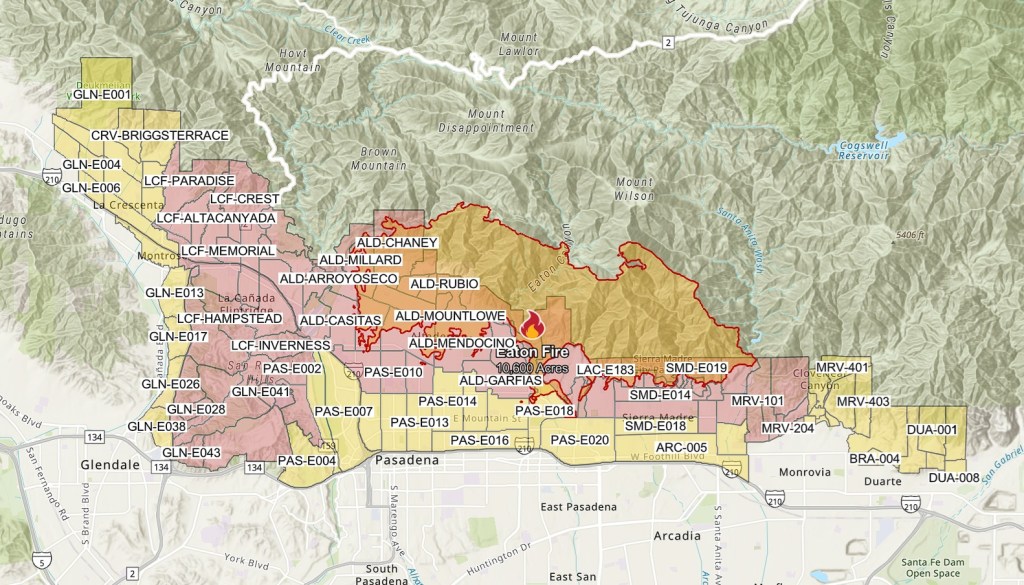
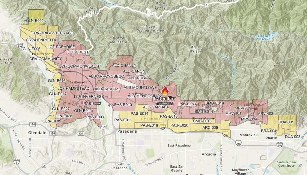
The Eaton fire map reveals how quickly the wildfire has spread in Los Angeles, as firefighters continue to battle the blaze in Pasadena, Altadena, and La Cañada Flintridge. The fire was first reported on January 7 at 6:18 PM PT, and since then, it has burned over 2,200 acres in less than 24 hours, rivaling the size of the Palisades fire that’s also ravaging LA County. The perimeter of the wildfire has rapidly expanded overnight, with multiple zones under mandatory evacuation orders and evacuation warnings. Here’s what we know so far about the Eaton fire in California today.
What is the Eaton fire map now?
[Update 2] The status update on January 9, 4:29 AM PT, indicates that the fire’s spread is still limited to the 10,600 acres and that the containment level is still at 0%. That said, the Eaton fire map does show in red where the blaze is active. According to the Associated Press, over 2,000 structures have been destroyed so far between the Palisades fire and Eaton fire.

[Update] 10,600 acres have burned so far, according to the latest status update of the Eaton fire map on January 8 at 10:55 AM PT. Like the Palisades fire, it remains at 0% containment.
[Original] The Eaton fire map, as of January 8 at 9:00 AM PT, shows that 2,227 acres have burned and that it is still at 0% containment. Over 30,000 residents in the area are under evacuation orders, noted by the zones in red below, to leave their homes.

[Note: The map above says “400 acres” but a later status report at 8:28 AM corrects this, noting the size of the fire is still at 2,227 acres.]
In a press conference on Wednesday morning, per CNN, county Fire Chief Anthony C. Marrone stated that the Eaton fire is still burning throughout Altadena, Pasadena, and the Angeles National Forest. He emphasizes that the “fire is growing,” and the latest status report notes that “Red Flag high wind conditions are expected to continue until Thursday evening.”
Two civilians have died due to the fire, with their cause of death unknown. Over 100 structures have been destroyed and many have suffered “a number of significant injuries.” Los Angeles County Sheriff Robert Luna said on Wednesday that more than 13,000 additional structures remain at risk. Schools within the Pasadena Unified School District were closed on Wednesday.
The cause of the Eaton Fire is yet unknown and under investigation, though the spread of the blaze has been fueled by low humidity, dry foliage, and Santa Ana winds that have reached gusts over 50 miles per hour.
Firefighters are currently spread throughout LA County as they battle the Palisades Fire, Hurst Fire, and Woodley Fire.


