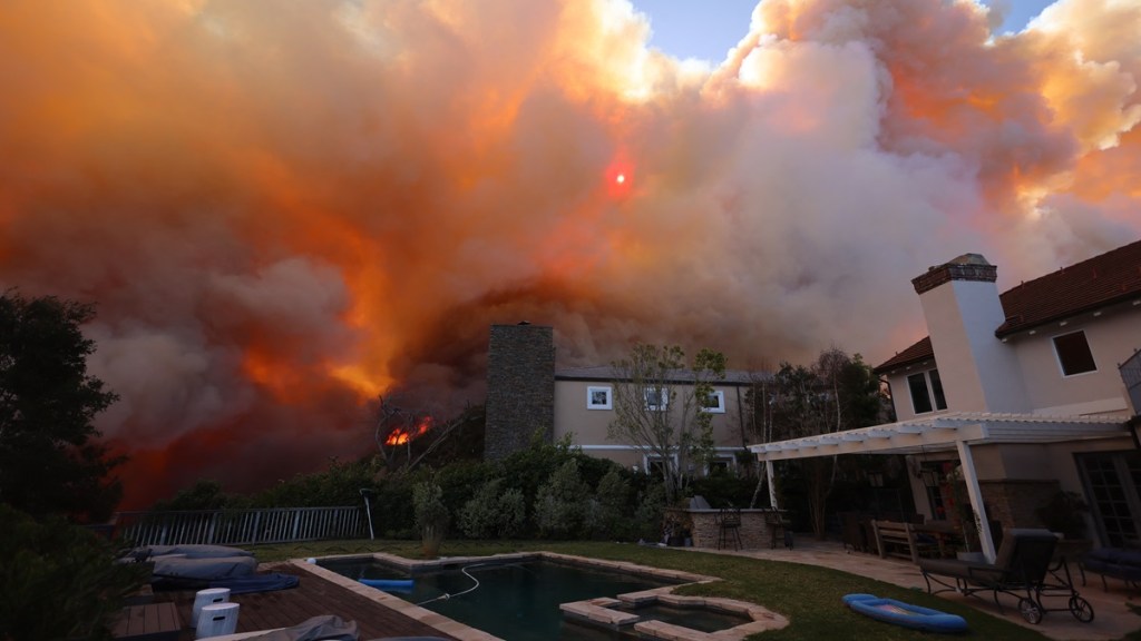
The Palisades fire map shows areas where the brush fire has spread so far and mandatory evacuation zones in Los Angeles. The blaze began on Tuesday morning, January 7, at around 10:30 AM PT near Piedra Morada Drive, according to the Los Angeles Fire Department. As reported by The Los Angeles Times. the brush fire began as two separate fires that moved rapidly across the area due to winds over 50 miles per hour. Here’s what we know so far about the Pacific Palisades fire.
What is the Pacific Palisades fire map now?
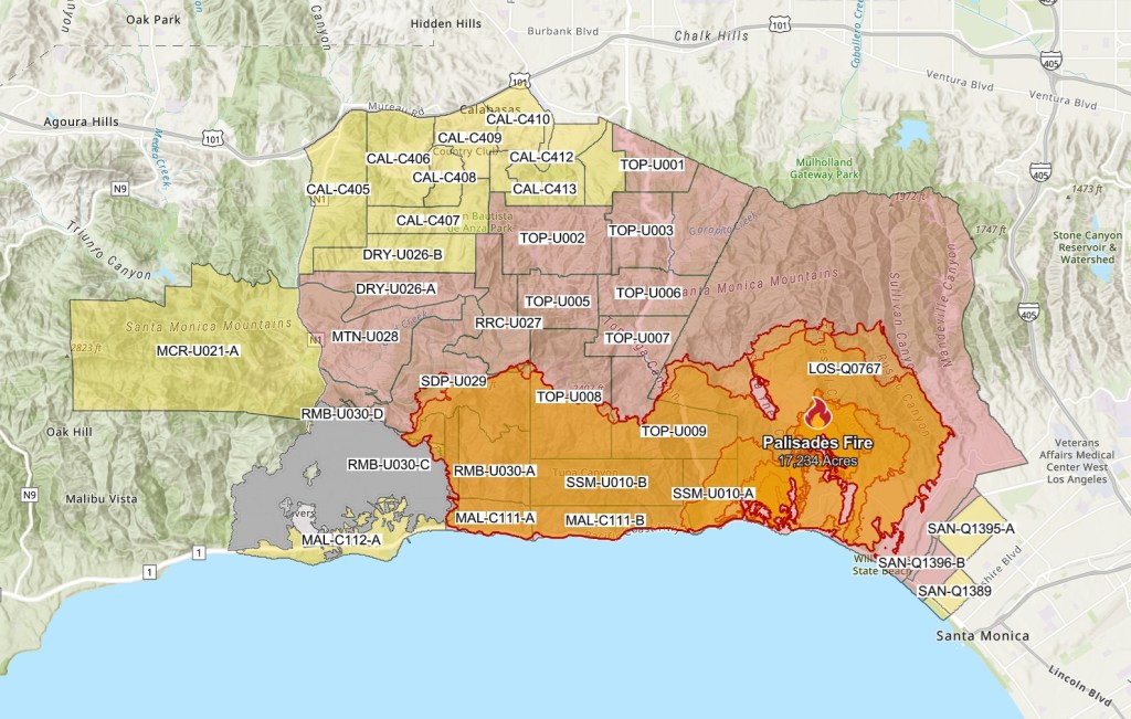
[Update 5] As of January 9, 4:39 AM PT, the Palisades fire has burned over 17,234 acres. Firefighters continue to fight the raging wildfire, which is still at 0% containment. New brushfires in Los Angeles, including the Sunset Fire and Lydia Fire, ignited overnight.
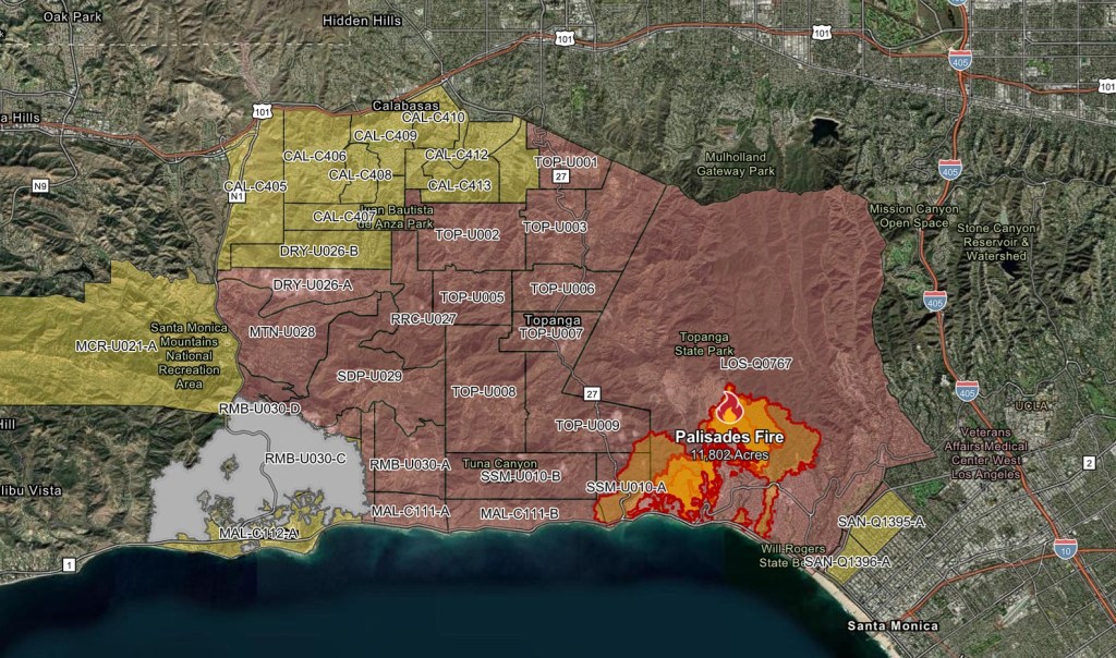
[Update 4] The latest status report of the Palisades fire map on January 8 at 11:45 AM PT indicates that it has spread over 11,802 acres. It still remains at 0% containment. As ordered by President Biden, per CNN, the Defense Department is sending assistance by way of ten Navy helicopters and multiple modular air fire fighting system units from the California National Guard and Nevada National Guard.
[Update 3] As of 7:50 AM PT on January 8, the Palisades fire has not expanded much since the last update. However. four new fires have emerged in the Los Angeles area, with the Eaton fire in Altadena and Sierra Madre growing to 2,227 acres, the Hurst fire near Newhall and O’Melveny Park impacting about 500 acres, and the Woodley fire in Woodley Avenue Park currently at 75 acres.
All four fires are at 0% containment, and have caused multiple road closures, including parts of the Pacific Coast Highway, Interstate 10, Interstate 210, and I-5 truck lanes, per CNN. More than 50,000 people in Los Angeles County have been ordered to evacuated thus far. Multiple homes have burned to the ground due to the multiple wildfires.
[Update 2] Fueled by intense winds, the Palisades fire has more than doubled in size to 2,921 acres by 8:40 PM PT. The LA Times reports that over 30,000 residents have evacuated to safer ground and that the blaze will be difficult to control given winds forecast to peak between 10 PM Tuesday and 5 AM Wednesday. An additional fire called the Eaton Fire for its proximity to Eaton Canyon near Altadena has also burned about 400 acres by 8:15 PM.

[Update] The Pacific Palisades fire has spread to 1,262 acres, with many new evacuation zones to the west. Here is the new fire map as of 6:00 PM PT.
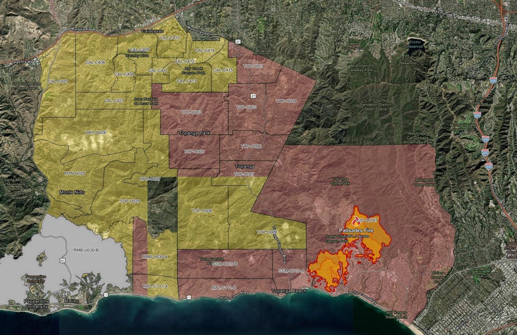
[Original] The Palisades fire map, as of 1:30 PM PT on January 7, shows that the blaze has spread across 200 acres. The status report at 1:34 PM PT states that containment is at 0%.
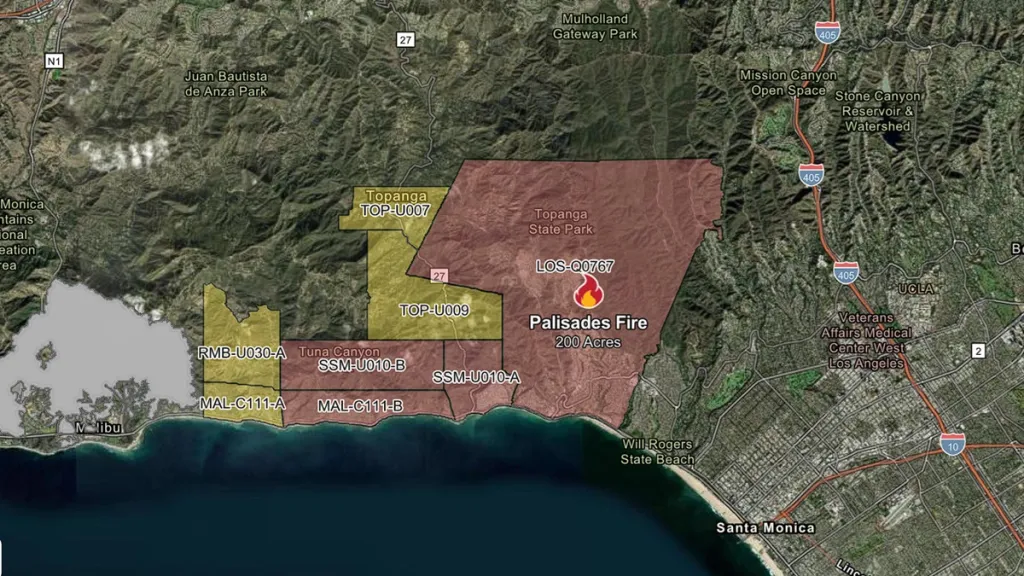
Mandatory evacuation orders have been declared for several areas in Los Angeles, specifically LOS-Q0767 near Topanga State Park and SSM-U010-B near Tuna Canyon.
The Los Angeles Fire Department has also issued mandatory evacuations in Topanga State Park and Will Rogers State Beach. It is suggested that residents in the surrounding area continue to monitor both the LAFD site and CAL FIRE for further evacuation warnings and orders.
The evacuation center for the Palisades fire is the Westwood Recreation Center located at 1350 South Sepulveda Blvd.
At 10:30 AM PT, the fire was already threatening several homes and the city warned residents close to the blaze to be prepared for evacuate “by gathering supplies and loved ones.” Firefighters were battling a structure fire in West Hollywood at 10:00 AM PT that had spread to brush near West Sunset Boulevard.
The high winds spreading the fire have been compared to similar Santa Ana winds that were partially responsible for the Mountain fire in Ventura County and Franklin fire in Malibu over the last two months.
The National Weather Service stated on Tuesday that the wind gusts were “strong, damaging, and potentially life-threatening.” CAL FIRE also issued an alert on Tuesday saying that “Southern California is facing a #CriticalFireWeather event through Thursday, with strong Santa Ana winds and low humidity creating extreme wildfire risks.”
A red flag warning has been issued for Wednesday and Thursday for various counties in Southern California from Santa Barbara and Los Angeles to San Diego.
